


GPS Kolida K50
Fitur Kolida K50:
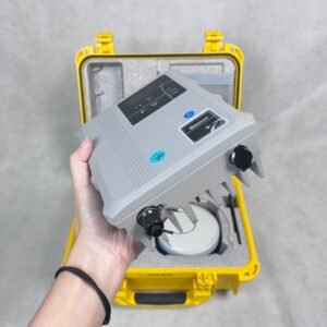
GPS RTK GNSS Kolida K50 adalah penerima GNSS RTK yang dirancang untuk memberikan akurasi pengukuran posisi yang luar biasa dalam berbagai aplikasi survei dan pemetaan. Selain itu, GPS RTK GNSS Visual 3D with EDM total station menawarkan akurasi RTK hingga tingkat sentimeter, sehingga, sangat ideal untuk pekerjaan yang membutuhkan presisi tinggi. kemudian, dilengkapi dengan sertifikasi IP68, yang berarti alat ini tahan terhadap debu dan air, Tak hanya itu, alat ini juga dilengkapi komunikasi, termasuk radio UHF internal, modem seluler, dan Bluetooth, dengan demikian, memberikan fleksibilitas dalam pengumpulan dan transfer data.
Spesifikasi GNSS Kolida K50 :
| GNSS Performance | |
| Channels | 1,698 |
| GPS | L1C, L1C/A, L2C, L2P(Y), L5 |
| GLONASS | G1, G2, G3 |
| BDS | B1l, B2l, B3l, B1C, B2a, B2b |
| GALILEO | E1, E5a, E5b, E6, AltBoc* |
| QZSS | L1, L2C, L5 |
| SBAS | L1* |
| IRNSS | L5* |
| MSS L-Band* | Reserve |
| Positioning Output Rate | 1Hz~20Hz |
| Initialization Time | <10s |
| Initialization Reliability | >99.99% |
| Positioning Accuracy | |
| Code Differential GNSS Positioning | H : 0.25m+1ppm (RMS) V : 0.50m + 1 ppm (RMS) |
| GNSS Static | H : 0.25mm+0.5 ppm (RMS) V : 3.5mm + 0.5 ppm (RMS) |
| Static (Long Observation ) | H : 2.5 mm + 0.1 ppm RMS V : 3 mm + 0.4 ppm RMS |
| Rapid Static | H : 2.5 mm + 0.5 ppm RMS V : 5 mm + 0.5 ppm RMS |
| PPK | H : 3 mm + 1 ppm RMS V : 5 mm + 1 ppm RMS |
| RTK(UHF) | H : 8 mm + 1 ppm RMS V : 15 mm + 1 ppm RMS |
| RTK(NTRIP) | H : 8 mm + 0.5 ppm RMS V : 15 mm + 0.5 ppm RMS |
| SBAS Positioning | Typically<5m 3DRMS |
| RTK Initialization Time | 2~8s |
| IMU Tilt Angle | 0°~60° |
| Hardware Performance | |
| Dimension | 134mm(W) ×134mm(L) × 79.1mm(H) |
| Weight | 860g (battery included) |
| Material | Magnesium aluminum alloy shell |
| Operating Temperature | -45℃~+75℃ |
| Storage Temperature | -55℃~+85℃ |
| Humidity | 100% Non-condensing |
| Waterproof /Dustproof | IP68 standard, protected from long time immersion to depth of 1m IP68 standard, fully protected against blowing dust |
| Shock/Vibration | Withstand 2 meters pole drop onto the cement ground naturally |
| Power Supply | 6-28V DC, overvoltage protection |
| Battery | Inbuilt 6800mAh rechargeable Lithium-ion battery |
| Battery Life | 16h (static) 12h (rover) 10h (built-in UHF base) |
| Communications | |
| I/O Port | 5-PIN LEMO interface (external power port + RS232) Type-C interface (charge + OTG+ Ethernet) UHF antenna interface |
| Internal UHF | Radio receiver and transmitter |
| Frequency Range | 410-470MHz |
| Communication Protocol | Farlink, Trimtalk, SOUTH |
| Communication Range | Typically 5-8 km with Farlink protocol, up to 12-15 km in optimal condition |
| Bluetooth | Bluetooth 3.0/4.1 standard, Bluetooth 2.1 + EDR |
| NFC Communication | Support |
| Modem | 802.11 b/g/n standard wifi and 4G |
| Data Storage/Transmission | |
| Storage | 16GB SSD internal storage Support external USB storage (OTG) The customizable sample interval is up to 20Hz |
| Data transmission | Plug and play mode of USB data transmission Supports FTP/HTTP data download |
| Data format | Static data format: STH, Rinex2.01, Rinex3.02 and etc. Differential data format: RTCM 2.1, RTCM 2.3, RTCM 3.0, RTCM 3.1,RTCM 3.2, CMR GPS output data format: NMEA 0183, PJK plane coordinate, Binary code Network model support: VRS, FKP, MAC, fully support NTRIP protocol |
| Sensors | |
| Camera | Front Camera 8MP, Bottom Camera 2MP |
| Electronic bubble | Controller software can display electronic bubble, checking leveling status of the carbon pole in real-time |
| Thermometer | Built-in thermometer sensor, adopting intelligent temperature control technology, monitoring and adjusting the receiver temperature |
| User Interaction | |
| Operating system | Linux |
| Buttons | Single button |
| Indicators | Bluetooth, satellites, data, charging and power indicators |
| Web interaction | With access to Web UI via WiFi or USB connection, users can monitor the receiver status and change the configurations |
| Voice guidance | Chinese/English/Korean/Spanish/Portuguese/ Russian/Turkish/French/Italian |
| Secondary development | Provides secondary development package, and opens the OpenSIC observation data format and interaction interface definition |
| Cloud service | The powerful cloud platform provides online services like remote management, firmware updates, online registers, etc |
Pelengkapan GPS RTK GNSS Kolida K6
- Radio External
- Tongkat Tiang
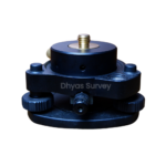
- Tribrach + Adapter
- Data Pengontrol
Include Penjualan :
- 1 Set Base + Rover
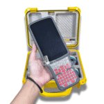
- 1 Unit Controller Original
- 1 Unit Radio External + Antena External
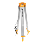
- 2 Unit Tripod Statif
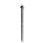
- 1 Unit Stik Pole Jalon
- 1 Unit Tribrach + Adapter
- Software Pengolahan data + 3D Modeling
- Manual book
- Lisensi All In Permanent
- Garansi 1 Tahun
- Free training Sampai bisa
- Free Konsultasi 7×24
Tambahan :
(Bisa Pakai PPN + Mengeluarkan Faktur Pajak)
happy shopping !!


Ulasan
Belum ada ulasan.