


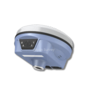
GPS Geodetik Satelit S1
Fitur Satelit S1 :
GPS Geodetik Satelit S1 adalah alat GPS RTK GNSS yang dirancang untuk memberikan pengukuran posisi dengan akurasi tinggi dalam berbagai aplikasi survei dan pemetaan. Pada dasarnya, alat ini memanfaatkan teknologi GNSS (Global Navigation Satellite System) untuk menerima sinyal dari berbagai konstelasi satelit, termasuk GPS, GLONASS, BeiDou, dan Galileo. Selanjutnya, Satelit S1 menggunakan teknologi RTK (Real-Time Kinematic) untuk memberikan koreksi real-time, sehingga mencapai akurasi pengukuran hingga tingkat sentimeter. Selain itu, alat ini didesain untuk kemudahan penggunaan dan portabilitas, menjadikannya ideal untuk pekerjaan lapangan yang dinamis.
Lebih lanjut, GPS RTK GNSS Satelit S1 dilengkapi dengan berbagai fitur canggih yang meningkatkan produktivitas dan efisiensi. Kemudian, alat ini memiliki desain yang ringkas dan ringan. Tidak hanya itu, baterai tahan lama memungkinkan penggunaan sepanjang hari tanpa perlu sering mengisi ulang. Selain itu, Satelit S1 juga dilengkapi dengan konektivitas nirkabel, seperti Bluetooth dan Wi-Fi, untuk memudahkan transfer data dan integrasi dengan perangkat lain.
Spesifikasi:
| GNNS Feature | |
|---|---|
| Channel | 1598 |
| GPS | L1, L1C, L2C, L2P, L5 |
| GLONASS | L1C/A, L1P, L2C/A, L2P, L3* |
| BDS | BDS-2: B1l, B2l, B3l |
| BDS-3: B1l, B3l, B1C, B2A, B2B* | |
| GALILEOS | E1, E5A, 35B, 36C, AltBOC* |
| SBAS | L1* |
| IRNSS | L5* |
| QZSS | L1, L2C, L5* |
| MSS-LBAND | BDS-PPP |
| Positioning Output Rate | 1Hz~20Hz |
| Initialization Time | < 10s |
| Initialization Reability | > 99.99% |
| Positioning Precision | |
| Code differential GNSS positioning | H : 0.25 m + 1 ppm RMS V : 0.50 m + 1 ppm RMS |
| GNSS static | H : 2.5 mm + 0.5 ppm RMS V : 5 mm + 0.5 ppm RMS |
| Real-time kinematic (Baseline<30km) | H : 8 mm + 1 ppm RMS V : 15 mm + 1 ppm RMS |
| SBAS positioning | Typically < 5m 3DRMS |
| RTK initialization time | 2 ~ 8s |
| IMU tilt compensation | Additional horizontal pole tip uncertainty typic-ally less than 10mm + 0.7 mm/° tilt down to 30° |
| IMU tilt angle | 0° ~ 60° |
| Hardware Performance | |
| Dimension | 130mm(W) ×130mm(L) × 80mm(H) |
| Weight | 790g (battery included) |
| Material | Magnesium aluminum alloy shell |
| Operating temperature | -45° C~ +75° C |
| Storage temperature | -55° C ~ +85° C |
| Humidity | 100% Non-condensing |
| Waterproof/Dustproof | IP67 standard, protected from long time immersion to depth of 1m IP67 standard, fully protected against blowing dust |
| Shock/Vibration | Withstand 2 meters pole drop onto the cement ground naturally |
| Power supply | 6-28V DC, overvoltage protection |
| Battery | Inbuilt 7.4V 6800mAh rechargeable, Li-ion battery |
| Battery life | 15h(Rover Bluetooth mode) 10h (Base Mode) |
| Communications | |
| I/O Port | - 5-PIN LEMO external power port + RS232 - Type-C(charge, OTG to USB disk - data transfer with PC or phone, Ethernet) - 1 UHF antenna TNC interface |
| Internal UHF | 2W TX and RX |
| Frequency range | 410 - 470MHz |
| Communication protocol | Farlink, Trimtalk450s,HUACE, Hi-target, Satel |
| Communication range | Typically 5-8km |
| Bluetooth | Bluetooth 3.0/4.1 standard, Bluetooth 2.1 + EDR |
| NFC Communication | Realizing close range (shorter than 10cm) automatic pair between receiver and controller (controller requires NFC wireless communication module else) |
| WIFI | |
| Modem | 802.11 b/g standard |
| WIFI hotspot | AP mode, Receiver broadcasts its hotspot form web UI accessing with any mobile terminals |
| WIFI datalink | Client mode, Receiver can transmit and receive correction data stream via WiFi datalink |
| Data Storage/Transmission | |
| Storage | 4GB SSD Automatic cycle storage (The earliest data files will be removed automatically while the memory is not enough) |
| Data transmission | Support external USB storage Plug and play mode of USB data transmission |
| Data format | - Static data format: STH, Rinex2.01, Rinex3.02 and etc. - Differential format: RTCM 2.3, RTCM 3.0, RTCM 3.1, RTCM 3.2 - GPS output data format: NMEA 0183, PJK plane coordinate - Network model support: VRS, FKP, MAC, fully support NTRIP protocol |
| Sensors | |
| Electronic bubble | Controller software can display electronic bubble, checking leveling status of the carbon pole in real-time |
| IMU | Built-in IMU module, calibration-free and immue to magnetic interference |
| Thermometer | Built-in thermometer sensor, adopting intelligent temperature control technology, monitoring and adjusting the receiver temperature |
| User Interaction | |
| Operating system | Linux |
| Buttons | One button |
| Indicators | 5 LED indicators(Satellite, Charging, Power, Datalink, Bluetooth) |
| Web interaction | With the access of the internal web interface management via WiFi or USB connection, users are able to monitor the receiver status and change the configurations freely |
| Voice guidance | It provides status and operation voice guidance, and supports Chinese/English/ Korean/Spanish/Portuguese/Russian/Turkish |
| Secondary development | Provides secondary development kit, and opens the OpenSIC observation data format and interaction interface definition |
| Cloud service | The powerful cloud platform provides online services like remote manage, firmware update, online register and etc |
Include Penjualan :
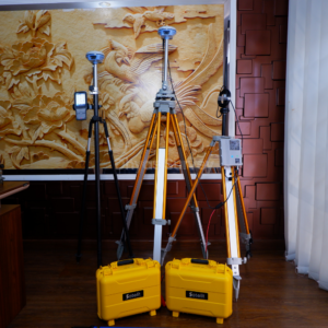
- 1 Set Base + Rover
- 1 Unit Controller Original
- 1 Unit Radio External + Antena External
- 2 Unit Tripod Statif
- 1 Unit Stik Pole Jalon
- 1 Unit Tribrach + Adapter
- Software Pengolahan data
- Manual book
- Lisensi All In Permanent
Aftersale :
- Garansi 1 Tahun
- Free training Sampai bisa
- Free Konsultasi 7×24
Tambahan :
(Bisa Pakai PPN + Mengeluarkan Faktur Pajak)
Download Brosur GPS Receiver Satelit S1
happy shopping !!
note:
*sertakan video unboxing untuk klaim garansi.
*apabila tidak terdapat video unboxing maka klaim garansi tidak berlaku.
*harga dapat berubah sewaktu-waktu tanpa pemberitahuan terlebih dahulu.
*mohon tanya ketersediaan barang terlebih dahulu.
*barang selalu kami cek terlebih dahulu sebelum di kirim.
*barang di toko kami di jamin original dan baru.
waktu pengiriman :
*senin – jumat pukul 11.00 – 15.30 barang langsung dikirim.
*sabtu pukul 11.00 barang langsung dikirm.
*hari minggu dan libur nasional, dikirim hari berikutnya.


aldi –
Receiver ini sangat cocok dengan pekerjaan saya saat mengukur batas wilayah. tapi tidak hanya itu, alat ini bisa juga digunakan untuk bathimetri dan PPK drone.
Geo Survey –
Akurasi bagus untuk Merk china, teknology sekarang mantap fixed dibawah rimbun dan gedung gedung tinggi